
Historical Tour of Ruppendorf
As part of the preparations for the 675th anniversary celebrations, the “Historical Tour of Ruppendorf” project was launched. The aim was to create a lasting memento for residents and visitors beyond the anniversary itself.
The tour at a glance:
- 24 stations with historically significant sites
- Total length: approx. 12 kilometers
Information material:
- Printed folding map (1,000 copies available at Landmarkt)
- Digital version on the Ruppendorf website (also available in English)
- Additional images and in-depth information available online
Project partners:
- Ruppendorf lebt! e. V.
- Committed citizens
- Local historians
- Local advisory board
The signs were erected on October 21, 2023 as part of a work assignment.
Discover the 24 stations and experience Ruppendorf up close!
Interactive map
Download GPX trackAll 24 stations at a glance
The Water Castle Ruins
Ruins of a medieval border fortress from the 12th/13th century – Ruppendorf's landmark.
View stationGym Ruppendorf
Built in 1924, renovated several times – replaced in 2015 by a new building.
View stationSexton’s House & First...
Built around 1578 – Ruppendorf's first school and home of the sexton, now a private residence.
View stationVolunteer Fire Department
Founded in 1924, part of the Klingenberg Volunteer Fire Department with a long tradition.
View stationThe “Siedlung” Residential Area
Formerly Tännigtwiese – gradually developed into today's residential area starting in the 1930s.
View stationThe Church of Ruppendorf
Evangelical Lutheran Church, newly built in 1674, with Gothic portal and winged altar from 1520.
View stationThe Restaurant “Erbgerichts-Gasthof”
Traditional inn with a liquor license since the village was founded, now run by the Hartmann family.
View stationThe Parish Property
Parish office since 1557 – the barn, dating from around 1660, is one of the oldest buildings.
View stationThe “Old School”
School building from 1878, used until 1990, now a farmers' market and service center.
View stationThe Area “Mühlgraben”
Historic moat leading to Flathe Mill – today a quiet residential area with rural charm.
View stationThe Kirchner’s Forge
Built between 1550 and 1600, demolished in 1977 – well-documented list of owners since 1723.
View stationThe Flathe Mill
Village mill since at least the 14th/15th century – operated by the Flathe family.
View stationThe Flagellation Colum
Sandstone pillar from the 14th/15th century, rediscovered in 1932 – now a listed building.
View stationThe Dairy Moritz
Founded in 1891, known for Othello ice cream – closed in 1990 by the Treuhand privatization agency.
View stationFrom Sattler to Interior...
Family business since 1837 – now in its 7th generation, specializing in modern interior design.
View stationErich Wunderwald
Founder of the “Ruppendorfer Ruinenspatzen” in 1946 – an Erzgebirge dialect group with 1,000 shows.
View stationThe “New School”
Opened 1990, primary school and kindergarten since 2007 – a learning place for ~130 children.
View stationThe Hill “Steinberg”
432 m a.s.l. – Transmission mast, gray gneiss formation, and panoramic views over Ruppendorf.
View stationThe Hill “Grosser Steinberg”
Ruppendorf's highest point (493.7 m) in Bauernbusch – with views stretching to Saxon Switzerland.
View stationThe Rear Outworks or...
Former agricultural estate, owned by the Göbel family for 328 years, now privately owned.
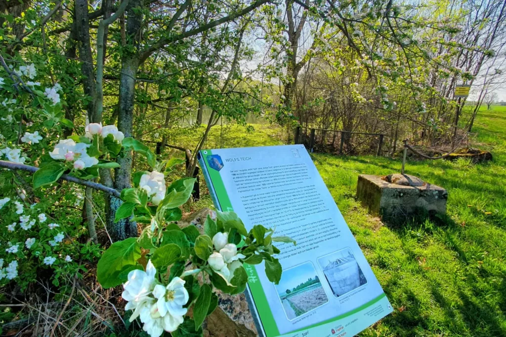
View stationThe Pond „Wolf’s Teich“
At least 443 years old – once a royal fish pond, later a drinking water reservoir.
View stationThe Flood Retention Basin
Completed in 2015 – protects Ruppendorf and Höckendorf from flooding up to a 20-year event.
View stationThe Outworks of Ruppendorf
First mentioned in 1349 – a daycare center opened on the site of the demolished Zentralhof in 2020.
View stationDecorative Arch
Since 2012: among the largest Schwibbögen in the Ore Mountains – 7 m wide, a Christmas market icon.
View station