BOARD 10 - THE AREA "MÜHLGRABEN"
The area along the „Mühlgraben“ has been shaped by a long history of settlers. When you take a walk along the „Mühlgraben“ today, you walk past historic farms, which until today show traces of a historic “Waldhufendorf”, a village with a central brook, a main route, meadows, farm grounds, arable farm land and woods.
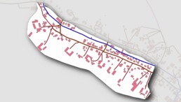
Today’s street “Am Mühlgraben” was named after the former 530 meters long water ditch which branched off the stream course at the former Kirchner’s forge (cf. Information board 11) and supplied the Flathe Mill (cf. information board 12) with water. As the map shows, in 1790 the brook still ran its original course and apart from the farms and some houses, the meadows and wetlands remained undeveloped. Supposedly in 1928, the “Mühlgraben” was filled up and the brook’s course was straightened out.
The straightening of the brook “Höckenbach” created arable land. With the beginning of the 1930s the area was developed with the gradual building of houses. More houses were built between 1970 and 1980. As a consequence, the risk of flooding increased. The houses blocked the former path the water had used to run to the brook until the hill “Steinberg” (Information board 18).
The “Mühlgraben” counted 49 buildings in 1790 and since then has amounted to 134 buildings in 2023 which can still be seen today. Today, the “Mühlgraben” presents itself as a harmonic settlement which despite a number of modern buildings has kept its rural charme.