BOARD 18 - THE HILL "STEINBERG"
We find ourselves at the bottom of the “Steinberg” hill that measures 432 meters above sea level. For the local residents this hill represents an important landmark. The mountain crest shows how changing social needs have shaped the landscape. While a topographic map of 1881 still shows the area as agricultural land, it was afforested with conifers in the 1930s.
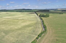
In 1970 a distinctive transmitter mast was erected which until today serves as a transmitter mast for mobile communications. This is why the locals affectionately call the hill “Umsetzer” (converter). The path, we find ourselves on, was created in the 1980s in order to navigate the increasing agricultural traffic more efficiently and to relieve Ruppendorf. Between 1986 and 1987 employees of “Zinnerz Alternberg” conducted significant blasting works in order to improve the path’s route. This resulted in a still today visible rock formation which along with the “Unteren Freiberger Graugneis” shows one of the oldest geological structures of the Ore Mountains. According to the Freiberg geologist Tichomirowa the age of the Rocks is estimated between 540 to 320 million years. The rocks that had been gained from the blasts have been used for road constructions, especially connecting roads from Ruppendorf to Paulshain and Beerwalde. Because of the extensive constructions works, the path received its nickname “Millionenweg”.
From this elevation we can enjoy an impressive panorama. If you take a look to the southern direction you can see the plateau of Ruppendorf that extends until Beerwalde and the wood “Bauernbusch” with the hill “Großer Steinberg” (Information board 19). This plateau area is marked by a rough climate, gentle hills and extensive hollows. Especially during the winter months and at the beginning of spring here is where you can witness the phenomenon of inverted atmospheric conditions. Instead of falling temperatures with an increasing altitude, cold air gathers in the lower parts which can lead to a temperature difference of up to 5 degrees Celsius in contrast to other neighbouring hills. The people of Ruppendorf can witness this climatic exception on a regular basis. The area that extends between our current location and Ruppendorf as well as the wood “Bauernbusch” has been used for agricultural purposes for centuries.