BOARD 5 - THE "SIEDLUNG" RESIDENTIAL AREA
The settlement in Ruppendorf is a small and secluded residential area that has experienced a lot of changes throughout the course of the centuries. The Oeder map from the time around 1580 shows the area of today’s settlement referred to as Tännigt. It used to be a large wet meadow which was crossed by several brooks. The maps below from around 1800 show that in this area the brooks had been straightened out or dewatered and that the meadows had been drained. This served as the basis for extensive future settlements.
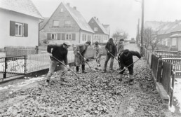
Originally two farms were located on the Tännigt meadow, which after the Thirty Years’ War were reconstructed in 1639. In 1927 the first new building was the motor vehicle hall at the “Freiberger Straße 2”, today’s address of the Voluntary Fire Brigade. It was not only home to two omnibuses that were used on the route between Edle Krone – Ruppendorf – Dippoldiswalde, but also to three residencies. A few years later three more buildings were erected. In 1934 the protocol book of the municipality tells that the settlement was extended to five semi-detached houses and regulations of the brooks were necessary. This means that the first new buildings at the time were created between 1930 and 1934. Since then the number of buildings has risen to 52. During the 1980s, the road to the settlement was paved with an extensive self-contribution by the local residents.